|
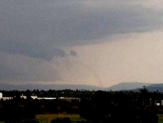
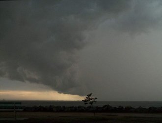
Reports of a "great shelf cloud" from Anthony Cornelius mid afternoon, who was chasing SW of Brisbane, raised my hopes of an interesting afternoon as a squall line became more and more organised on radar. As it moved east, the northern end of this line became quite intense on radar, and i decided to head out and intercept it. On my way north, i saw some fairly strong updrafts in the center of the line (which was now around 100km long). I decided to turn back south, and head for a lookout about 15 mins away. As i made my way there, a very long shelf cloud can into view, with precipitation on the southern and northern end, and little or no precipitation between them. I arrived at my lookout, and watched the line for a period of about 15 minutes. The southern end was more interesting features wise, and i kept a close eye on that. I glanced back towards the northern end for a few seconds and noticed a strange tornado like column extending from the leading edge of the line, to the top of Mt Em. At first i thought it was smoke! as i had seen something similar in a chase report only a week or so earlier, but after about 20 seconds i thought it was interesting enough to take a picture (first one below). Over the next few minutes, i watched this column retain pretty much the same shape, but become fainter and fainter until it completely dissipated!!!! It was at this stage i realised i had just witnessed a Tornado! Or to be more specific, a Gustando.
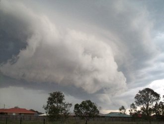
I continued to photograph a cell which had developed north of the southern most precipitation when i first arrived at the lookout. This developed a slightly lower shelf cloud, and quickly became quite photogenic.
It was now starting to get very interesting! I decided to move to another lookout in order to stay ahead of it, and keep taking pictures. This turned out to be a good move - only 10 minutes down the road, i turned around to see a spectacular shelf cloud! with the southern end of the line building out, and some spectacular and sections of the shelf cloud looking very grunty. I took the pan below (thanks to Daniel Weatherhead from SSC for digitally joining the pictures!!)
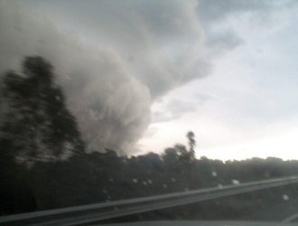
I quickly jumped in the car and headed for the highway, hoping that i could go north and stay ahead of the line. Along the way the northern end of this line also took on a 'bulging out' appearance.
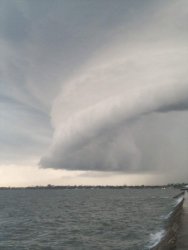
I finally got to another lookout, after lightning my way through some very annoying traffic. The sight that greeted me was nothing short of SPECTACULAR - the shelf cloud to the south was now bulging out in a spectacular fashion!!! with smooth laminar appearance to it, and generally extremely photogenic!!!! I took lots of pictures.
I tried to continue north and stay out of the rain, but heavy traffic slowed me down, and by the time i got to a lookout i was under the shelf cloud, and rain started falling.
Winds up to 35 knots or so were experienced,
with some mostly moderate but briefly heavy rain. Lightning was surprisingly
infrequent at this stage, although their were still some Cg's within 1km
on my way home - and one within 100m just as i walked in the door!
Chase report by Ben Quinn
|