
 WIDESPREAD SHOWERS
AND THUNDERSTORMS - OCTOBER 4, 1999
 Thunderstorms
in central northern NSW and the the QLD southern interior the day before
were a good sign for storms in SE QLD the next day. The next day
(october 4) the early morning satellite pictures were glorious, with a
line of showers and storms over the western/central darling downs and extending
down into NSW. Early morning storms on the darling downs are a good
indicator of severe storms in SE QLD later on in the day. Unfortunately
there was a lot of mid/high level cloud over most parts during the morning.
Although there were already storms on the downs, we really wanted
the cloud to clear to allow for surface heating. Sure enough, after
some early afternoon showers and storms (one of which moved over Redcliffe
dumping 19mm in 10-15 mins), the cloud began to clear. Lightning
tracker (which had been humming along with up to 50 whites all morning)
started to become more active, with scattered activity over the downs,
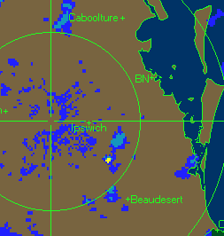
western SE QLD and NE NSW. Activity continued through the afternoon,
mainly in southern and western SE QLD. During the late afternoon/early
evening a line of storms west of Brisbane started to get organised and
moved over Brisbane. There was a great bow in the line of storms
as it approached Brisbane. There were probably allot more severe
storms in the SE QLD that went unreported. The following damage/incidents
were reported to media or the BOM. Thunderstorms
in central northern NSW and the the QLD southern interior the day before
were a good sign for storms in SE QLD the next day. The next day
(october 4) the early morning satellite pictures were glorious, with a
line of showers and storms over the western/central darling downs and extending
down into NSW. Early morning storms on the darling downs are a good
indicator of severe storms in SE QLD later on in the day. Unfortunately
there was a lot of mid/high level cloud over most parts during the morning.
Although there were already storms on the downs, we really wanted
the cloud to clear to allow for surface heating. Sure enough, after
some early afternoon showers and storms (one of which moved over Redcliffe
dumping 19mm in 10-15 mins), the cloud began to clear. Lightning
tracker (which had been humming along with up to 50 whites all morning)
started to become more active, with scattered activity over the downs,
western SE QLD and NE NSW. Activity continued through the afternoon,
mainly in southern and western SE QLD. During the late afternoon/early
evening a line of storms west of Brisbane started to get organised and
moved over Brisbane. There was a great bow in the line of storms
as it approached Brisbane. There were probably allot more severe
storms in the SE QLD that went unreported. The following damage/incidents
were reported to media or the BOM.
Damage Reports
20 000 homes blacked
out from the southern suburbs of Brisbane north to the Gympie area.
Reports of a car
swept off the road by flash flooding in Sunnybank Hills. Flash flooding
also cut roads in Durack, and other SW Brisbane suburbs.
Powerlines fell on
a police car in Bundaba as the storms struck, trapping a police woman inside.
She was rescued unharmed, but in a state of shock. 3 people died
in this same suburb last year as they were pulling fallen tree branches
off hidden live power lines brought down by storms.
A council worker
was sucked into a storm water drain whilst working in the Pacific Motorway
area. He was rescued and taken to hospital.
Small hail (around
pea size) was reported in Amberly.
Rainfall
The Chasers
Ben Quinn (Redcliffe)
- 19mm from a storm at approx 1:30, a further 37mm from the evening storms
- a total of 56mm.
Anthony Cornelius
(Belmont) - Approx 23mm
James Chambers (Woodridge)
- 26mm
John Woodbridge (Mt
Crosby) - 16mm
John Sweatman (Burpengary)
- 42mm
The highest rainfall
reported to the Bureau of Meteorology was Toolara with 72mm.
Official BOM rainfall
totals
Darling Downs
and
Granite Belt
The Head - 52mm
Glenelg - 36mm
Dunmore - 35mm
Upper Pilton - 34mm
Oakington - 34mm
Toowoomba - 32mm
Woodspring - 32mm
Warwick - 31mm
|
South East
Coast and
Brisbane Metropolitan
Toolara AWS - 72
Browns Plains -
61
Darlington - 60
Tarome - 51
Beaudesert - 50
Moogerah Dam - 49/2
Miami - 49
Coolangatta - 44
Boonah - 44
Foxley - 43
Redcliffe - 42
Romani - 41
Beechmont - 41
Cooran - 40
Maroon Dam - 40
Mt Mee - 37
Morayfield - 36
Lytton - 34
Canungra - 34
Wivenhoe Dam - 32
Sandgate - 32
Banyo - 32
Somerset Dam - 31
Boondall - 31
Point Lookout -
31
Boreen Point - 30
Greenbank - 30 |
Wide Bay and
Burnett
Miva - 66
Biggenden - 56
Rainbow Beach -
49
Howard - 44
Builyan - 40
Double Is Pt - 40
Mt Binga - 39
Imbil - 38
Goomboorian - 37
Gayndah - 35
Hervey Bay - 32
Goomeri - 31
|
If you have any additional
information on these storms, a personal account, pictures, or anything
at all, please email
me!
|
