
 SHOWERS AND THUNDERSTORMS
- NOVEMBER 5, 2000
Showers and Storms
developed throughout SE QLD and in coastal parts of NE NSW again on this
day, with several strong or severe cells. The activity once again
developed by late morning in NE NSW, and initial development in SE QLD
wasn't far behind. Their were reports of hail from several locations
in SE QLD, but nothing in the severe range, although radar images suggested
it was quite possible in several locations.
Anthony Cornelius
chased on this day, scoring a spectacular wall cloud and some awesome hail
shafts! Click here
to see his chase report.
I chased in the northern
suburbs of Brisbane for the first half of the afternoon, and my summary
is below.
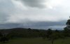
With the
budged starting to strain under the pressure of several storm days in a
row, i decided to 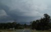 chase/observe
around my local location on this day. When i saw a fairly long and
thick chase/observe
around my local location on this day. When i saw a fairly long and
thick 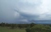 inflow
band on a newly developed Cb tower to my west in the early afternoon, i
knew it was going to be a good day. This soon developed into a storm,
and before long a nice well rounded shelf cloud was in view. I decided
to drive closer to this cell, which had now become quite lightning active,
but turned around when i received pea size hail mixed in with the anvil
precipitation! I stuck around the Burpengary/Caboulture area for
the next hour or so, watching quite a long shelf cloud develop. Lightning
at this stage was frequent at inflow
band on a newly developed Cb tower to my west in the early afternoon, i
knew it was going to be a good day. This soon developed into a storm,
and before long a nice well rounded shelf cloud was in view. I decided
to drive closer to this cell, which had now become quite lightning active,
but turned around when i received pea size hail mixed in with the anvil
precipitation! I stuck around the Burpengary/Caboulture area for
the next hour or so, watching quite a long shelf cloud develop. Lightning
at this stage was frequent at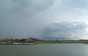 times, with many forked and strobing strikes - some of which strobed up
to half a dozen times! Further development around this storm, with
persistent heavy rain at times, made it hard to take pictures. However,
i managed to pull off the series seen below, showing the shelf cloud developing,
then another interesting base with inflow to the north ahead of it.
This base developed into quite a strong storm, with constant rolling thunder
and several nice Cg's - but once again heavy rain prevented me from taking
any pictures.
times, with many forked and strobing strikes - some of which strobed up
to half a dozen times! Further development around this storm, with
persistent heavy rain at times, made it hard to take pictures. However,
i managed to pull off the series seen below, showing the shelf cloud developing,
then another interesting base with inflow to the north ahead of it.
This base developed into quite a strong storm, with constant rolling thunder
and several nice Cg's - but once again heavy rain prevented me from taking
any pictures.
  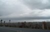  
I returned home to download the pictures
i had taken off my digital camera, and to have a look at radar. Radar
images, and an increasingly dark sky to the SW prompted me to drive out
towards Ipswich. On my approach lightning was on the increase, with
a seemingly very large cell moving NE towards the northern suburbs of Brisbane.
As i got closer it became apparent that this cell was featureless, and
i decided to park somewhere and let it move over the top of me. 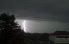 The
lightning was just amazing, with dozens of Cg's striking within 2km of
me, and some within 100m and strobing up to half a dozen times! With
only moderate rain and light winds, i decided to follow the storm NE.
The end result was over an hour of close lighting, and rain increasing
to heavy/very heavy at times. As the sun went down, several cells
became lightning active in an arc from the NW around to the SE, with some
lovely anvil crawlers and further spectacular Cg's. A lightning picture
(captured with a digital camera) taken from Ipswich was submitted by Dan
Keogh, and can be seen above. The
lightning was just amazing, with dozens of Cg's striking within 2km of
me, and some within 100m and strobing up to half a dozen times! With
only moderate rain and light winds, i decided to follow the storm NE.
The end result was over an hour of close lighting, and rain increasing
to heavy/very heavy at times. As the sun went down, several cells
became lightning active in an arc from the NW around to the SE, with some
lovely anvil crawlers and further spectacular Cg's. A lightning picture
(captured with a digital camera) taken from Ipswich was submitted by Dan
Keogh, and can be seen above.
When i arrived home, an email from John
Woodbridge at Mt Crosby alerted me to the fact that if i had of gone north
on a road from Ipswich, instead of doing a U turn thinking i was going
the wrong way, i would have seen everything he saw - which is summarised
below.
Translated to very nice conventional
squall line type storm at Mt. Crosby around 6:00pm. Heaps of lightning,
closest CG strike approx 200m. Total of 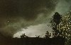 24mm
very welcome rain in around 30min. Only really showed pink on radar.
Looked green as it approached and appeared to have cyclonic rotation above
the shelf cloud. But no hail and not much wind once again.
The ideal observers storm I thought, all action but no damage. 24mm
very welcome rain in around 30min. Only really showed pink on radar.
Looked green as it approached and appeared to have cyclonic rotation above
the shelf cloud. But no hail and not much wind once again.
The ideal observers storm I thought, all action but no damage.
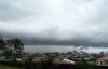
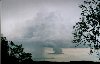
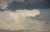
John also took several pictures of a large
cell around the Boonah area on this day. These pictures, and his
description of them, are below.
Shot (on the left) of large storm
over the Boonah area, storm is approx 80km SW from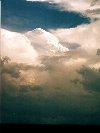 camera. Wall cloud and lowerings to the NW of precip area under
  new
updraft visible at top of photo. If you look carefully, just to the
right of the wall cloud you can just make out Cunninghams gap through the
lighter precip. Twin peaks of Mts. Mitchell & Cordeuex are around
1100m, the storm is a little in front that, so I guess the cloud base is
about 1000m. That puts the hard updrafts at the top of the picture
at around 12,000m. And another shot a bit later (on the right).
Unfortunately 80km is a bit far to get good detail of the lowerings. new
updraft visible at top of photo. If you look carefully, just to the
right of the wall cloud you can just make out Cunninghams gap through the
lighter precip. Twin peaks of Mts. Mitchell & Cordeuex are around
1100m, the storm is a little in front that, so I guess the cloud base is
about 1000m. That puts the hard updrafts at the top of the picture
at around 12,000m. And another shot a bit later (on the right).
Unfortunately 80km is a bit far to get good detail of the lowerings.
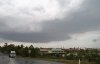
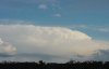
Meanwhile, looking the other way towards
Brisbane, this small cell over the Kenmore area had a bizarre little lowered
inflow region:
Flash flooding
was reported from southern Tweed Heads (on the NSW/QLD border) with up
to 30cm of water covering some roads!
Rainfall totals for central and southern QLD in the 24 hours to 9am November 6 were mostly light to moderate, with a hanful of heavier totals.
Some of the highest totals in central QLD were Baralaba (Capricornia) with 52mm, The Glebe (Central Highlands and Coalfields) 47mm, Collinsvilla (Central Coast and Whitsundays) 45mm and Taroom (Central Highlands and Coalfields) 41mm.
Some of the highest totals in southern QLD were Monto (Wide Bay and Burnett) with 108mm, Strathpine (South East Coast) 58mm Bundaberg (Wide Bay and Burnett) 55mm, Kenilworth (South East Coast) 51mm, and Wallumbilla (Maranoa and Warrego) with 49mm.
The atmosphere in
NE NSW was more supportive of severe activity and strong storms carved
a path of damage, dropping large hail and even sporing a torando!
The following information is courtesy of Michael Bath, Halden Boyd and
the ABC.
NIMBIN
A tornado has ripped
through the area from Stoney's Chute to Nimbin (a distance of 6km along
a ENE track), damaging several homes and bringing down large trees. A talkback
caller has reported 4.5cm diameter hail in Nimbin. This damage and touchdown
occurred just 10km ENE of where I encountered the hailstorm and 40knot
winds south of Kyogle from the same storm. Looks like I watched and experienced
the birth and effects of a supercell !! (Nimbin is about 30ks NNW of Lismore)
UKI
Hail the size of
"tennis balls" hit the small village of Uki, which is NE of Nimbin and
just ESE of Mount Warning.
DORRIGO
Hail the size of
"tennis balls" cut a swathe 3km long just west of the town shortly after
12 midday. Dozens of cars were smashed while their occupants were attending
a funeral.
Jason Rainforest managed to take some
pictures of a very large supercell moving through northern NE NSW during
the mid afternoon, these can be seen below.
NE NSW storm chaser and ASWA secretary
Michael Bath chased on this day - click here
to see his chase report and pictures.
Significant AWS
observations
Amberly recorded a rain rate of 34.8mm/h
at 5:37pm.
Coolangatta recorded a rain rate of 36mm/h
7:25pm, 62.4mm/h at 7:27pm, 126mm/h at 7:35pm and 109.2mm/h at 7:37pm.
In the 12 minutes between 7:25pm and 7:37pm 22.8mm of rain was recorded.
Gale force gusts of 34 knots were also recorded at 7:35 and 7:37pm.
Nambour recorded a rain rate of 48mm/h
at 6:52pm.
Credits
Thanks to Laurier Williams,
who provides the significant AWS observations on his website Australian Weather Links and News and also Michael Bath (from Australian
Severe Weather), Halden Boyd and the ABC for the information on
the NE NSW storms.
|
