
 SHOWERS AND THUNDERSTORMS
- NOVEMBER 7, 2000
Showers and storms
developed in SE QLD again on this day. Although no reports of hail
or severe weather have been received, radar images indicated several possible
hailstorms developed throughout the afternoon.
I was chasing SW
of Brisbane during the afternoon, and took the following pictures.
My summary is below
A SE change moved through Brisbane
the night before, and normally the chance of storms 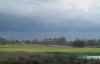 goes
out the window when this happens. However, an upper trough combined
with a weak inland trough caused showers and storms developed again, although goes
out the window when this happens. However, an upper trough combined
with a weak inland trough caused showers and storms developed again, although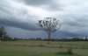 the most intense activity was mainly confined to inland parts. Early
afternoon radar images showing several heavy showers and one storm reaching
100mm/h+ intensity (indicating hail is possible/likely depending on the
atmospheric conditions) prompted me to drive west, away from the
coastal junk, in hope of seeing something. On my way west i drove
through
the most intense activity was mainly confined to inland parts. Early
afternoon radar images showing several heavy showers and one storm reaching
100mm/h+ intensity (indicating hail is possible/likely depending on the
atmospheric conditions) prompted me to drive west, away from the
coastal junk, in hope of seeing something. On my way west i drove
through 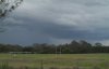 a
line of heavy showers, with a hanfull of lightning flashes seen.
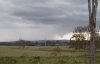
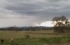
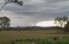
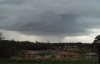
This wasn't very photogenic, and i decided to head SW towards an ever darkening
sky. Before long a line of activity was visible (first and second
pictures), and soon developed a small rainfoot on the northern end (third
picture). I a
line of heavy showers, with a hanfull of lightning flashes seen.
This wasn't very photogenic, and i decided to head SW towards an ever darkening
sky. Before long a line of activity was visible (first and second
pictures), and soon developed a small rainfoot on the northern end (third
picture). I 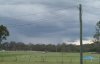 noticed
some interesting lowerings ahead of this rain foot, and decided to get
into a better position to photograph them (fourth picture). Unfortunately,
the area i was chasing in has a lot of trees, and it was hard to get pictures
of the lowerings developing. After 10 minutes of observing them through
gaps in the trees along the highway, i finally found a decent clearing
and took the series of pictures shown below. noticed
some interesting lowerings ahead of this rain foot, and decided to get
into a better position to photograph them (fourth picture). Unfortunately,
the area i was chasing in has a lot of trees, and it was hard to get pictures
of the lowerings developing. After 10 minutes of observing them through
gaps in the trees along the highway, i finally found a decent clearing
and took the series of pictures shown below.
   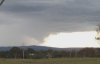
When i first saw this, i thought
Gustnado, but in hindsight it was probably just 'a nice lowering.
Whatever it was, it was quite exciting watching it unfold.
As i drove back to Brisbane, several large
cells with nice rain curtains developed. A picture of one of these
is shown below.
Rainfall in the 24 hours to 9am November
8 was generally light to moderate, with some isolated heavy totals.
Some of the highest include Fernfield (Wide Bay and Burnett) with 67mm,
Maroochydore (South East Coast) with 64mm, Tewantin (South East Coast)
59mm and Lake Cooroibah (South East Coast) 58mm.
|
