|
SEVERE HAILSTORMS IN SE QLD AND NE NSW - DECEMBER 10, 1999
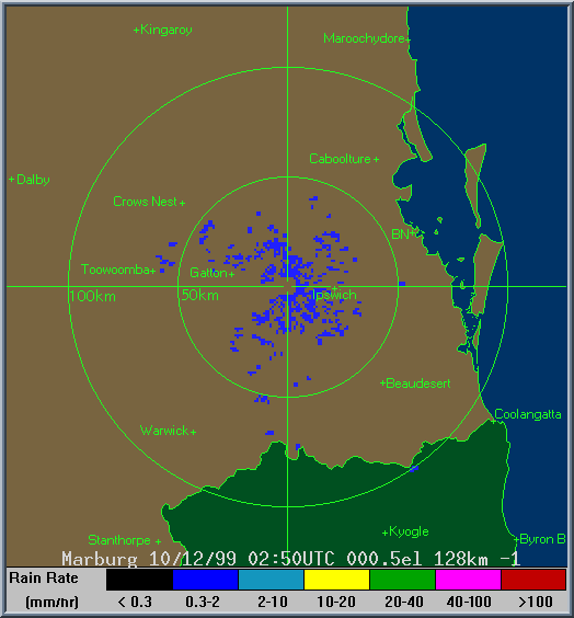
Severe storms have carved a path of damage through southern parts of SE QLD today. So
far reports of houses being demolished or unroofed, large hail (up to golf
ball size) in many suburbs on the gold coast and southern Brisbane, powerlines
brought down, trees uprooted and flash flooding. 35 000 houses were
without power yesterday evening. Some of these houses were still
without power early Saturday morning (December 11). Steve Baynham, on the Gold Coast, took the following captures from his video footage of a severe storm late in the afternoon. 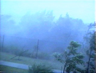 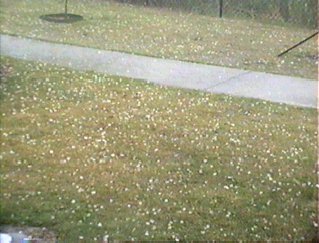 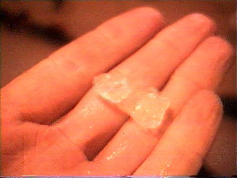 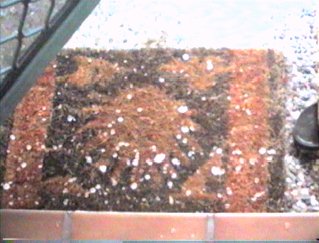 Another storm that moved through the southern suburbs of Brisbane late in the afternoon has been confirmed by the Bureau of Meteorology as a Supercell storm. This storm produced a tornado at Beenleigh. More information on this tornado can be found here. Anthony Cornelius and myself surveyed the damage from this storm. The damage inspection began just south of Redland Bay, with media reports and radar indicating that there would be some damage in this area. At the southern edge of Redland Bay, there were a handful of trees down, and a some branches down, however these were facing south (indicating a northerly wind). There are two possibilities for this,the first is very strong inflow into the main supercell thunderstorm (damage was again sighted several kilometres south of this). The second, is the squall line that moved across the Brisbane suburbs during the afternoon and evening from the WNW caused this damage. The latter is probably the most likely given that radar showed intensification of a cell in the line just as it moved over the area. After traveling south again, we found the main damage path. It was very sudden, with branches and the occasional tree down along a very defined border. The damage lasted for several kilometres, but the worst damage appeared to be on the northern edge. This might be somewhat bias due to the fact that most of the damage was tree/foliage damage, and the northern area was a residential area, whereas the southern area of thedamage path was a light industrial area. It appeared that hail was quite widespread, with leaves strewn all across the road and many gardens. Inspection of a housing estate revealed no structural damage, but lots of damage to gardens. Residents said hail was just under golf ball size, but was large enough to dent cars and crack a windshield. The hail and rain was blowing almost horizontally. A storm water drain that had dead grass piled up over the footpath suggested intense precipitation. We tracked south on the service road to inspect further damage, trees had large branches snapped off in the light industrial area. We lost the damage path in Beenleigh, due to road works causing quite a few ofthe service roads to be closed!!! However, we found it again in Jimboomba. The township had also been hit, with plenty of damage totrees, and hail damage was again evident. We weren't able to observe the entire damage path of the storm due to lack of roads, but essentially we tried to "criss-cross" across the damage path with the roads there were, and every time we did that, we encountered damage. There was no damage at Beaudesert, so we continued along Beaudesert-Boonah Rd. About 10-15km before Boonah, we began to observe damage along the road. Sometimes, huge trees had fallen down, and in some cases trees and/or large branches had fallen on the road, but had been pushed to the side already. Leaves were again over the road, indicating hail. The damage strip lasted all the way into Boonah. Ahouse had lost its roof on the SE outskirts of Boonah, the roof was blown about 70-80m away from the house. We then inspected the farming area around the outskirts. Large areas of grass had been pushed over onto the ground, it had resembled a truck driving over the grass! Along one strip of road, road signs had been ripped off poles, with one being ripped off and then tangled in a barb wire fence. All damage was thrown/pointing to the north/northeast indicating S-SW'ly straight line winds. There was no evidence of a tornado path, only straight line winds. In one section of forest, almost every tree had been badly damaged, snapped or blown over. There was no other structural damage tobuildings in the immediate vicinity. When finally entering the town of Boonah, there was a lot of damage to trees and gardens. Many residents were cleaning up the debris in their gardens, and the Boonah council had trucks and bobcats come in to help clean up the mess. We sighted 2 homes that lost their roof completely (tarped over completely), but never found the roof. We assumed that the roof had already been taken away. We also found the school that hadbeen badly damaged. Two blocks of classrooms both had their upper floors damaged, with one classroom having one wall nearly completely destroyed. The roof of both the blocks were blown well over 100m away. There was no other damage in the immediate vicinity, but the school was built on a hill in an exposed location, which may explain why the school suffered damage, and other houses surrounding the school didn't. Theschool had to be closed on Monday for storm damage repairs. A creek had risen well over its banks earlier on during the storm, this was evident from trees being pushed over nearby, and grass strewn through branches of nearby shrubs. Overall, there was no evidence of a tornado path, although one may have been possible, but didn't hit a populated/accessible area. It was difficult to put a figure on the wind speeds, but there is a high probability they approached destructive (130km/h) gusts at times in some areas. The largest report of hail was golf ball size. The damage pathconservatively was approximately 4km wide on average. The length of the damage path was from just south of Boonah, to Redland Bay. Approximately 80-100km long.
Report by Anthony
Cornelius
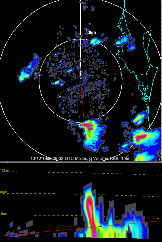
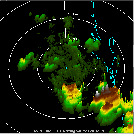
SUMMARY OF 3D AND HI RES RADAR IMAGES
The maximum height of the storm appears to be around the 18-19km mark, however there are sections of radar where the echos appear to go out of radars range (ie, orange echos above the white echos on the 3D images). The maximum scanning height of the radar is 20km, if this is true - then the actual highest tops could have infact reached in excess of 20km!!! You can also a small line of thunderstorms that moved through the northern, and eastern suburbs of Brisbane, these cells actually moved WNW to ESE, and still attained a height of approximately 12km, indicating that they were by no means weak. Almost any of the smaller/weaker cells that day moved in an ESE/SE, these were all multicells, indicating any left movers were most probably supercells. Radar
report by
Anthony
Cornelius
At about 4:45pm EST, the cricket on ABC radio was interrupted to give NSW-QLD border districts of SE Qld a STA for severe storms in 1-2 hours. Another report on this day is available on the Brisbane and SE QLD Storm Site, run by James Chambers. Click here or on the thumbnails below to go to the report.  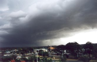
Report
by Ben
Quinn and Anthony
Cornelius
|