
 SEVERE STORMS
OVER THE DARLING DOWNS AND THE SE COAST DISTRICT
NOVEMBER 22,
1999
 Showers
and storms developed over the Darling Downs and western and southern parts
of SE QLD during the afternoon. The storms over the eastern
downs were reported as being "quite spectacular" by a group of storm chasers
currently chasing in the district. There were also reports of rotating
updrafts and wall clouds on the central Darling Downs during the afternoon.
The storms in SE QLD were much weaker at first, but late in the afternoon
a storm developed over western parts and began to move ENE. Before
long this storm was at max intensity on radar (100mm/h + rainfall rate
indicating hail is possible/likely depending on the atmospheric conditions)
and moving NE (all other storms were moving E). This storm
maintained max intensity for 40 mins straight on radar and was generally
looking quite strong. Just before 6pm the BOM issued a severe thunderstorm
warning for the western suburbs of Brisbane, including Ipswitch.
The storm continued to move NE towards the northern suburbs of Ipswich
and Brisbane. Showers
and storms developed over the Darling Downs and western and southern parts
of SE QLD during the afternoon. The storms over the eastern
downs were reported as being "quite spectacular" by a group of storm chasers
currently chasing in the district. There were also reports of rotating
updrafts and wall clouds on the central Darling Downs during the afternoon.
The storms in SE QLD were much weaker at first, but late in the afternoon
a storm developed over western parts and began to move ENE. Before
long this storm was at max intensity on radar (100mm/h + rainfall rate
indicating hail is possible/likely depending on the atmospheric conditions)
and moving NE (all other storms were moving E). This storm
maintained max intensity for 40 mins straight on radar and was generally
looking quite strong. Just before 6pm the BOM issued a severe thunderstorm
warning for the western suburbs of Brisbane, including Ipswitch.
The storm continued to move NE towards the northern suburbs of Ipswich
and Brisbane.
After 6pm I was able
to see lightning from this storm to my SW. It was quite frequent
with a stroke every second, even more frequent for short periods.
Just after 6:30pm i witnessed quite a spectacular sight! With lightning
running across the top of the storm from one end to the other and then
striking well outside the storm in a forked fashion! Awesome.
The storm continued
to move towards Brisbane, however by 7pm the lighting was decreasing steadily
(although there were still some spectacular anvil crawlers) and it started to slowly weaken on radar. By 7:30 the storm had dissipated,
leaving a cluster of thundery showers, which eventually dissipated as well
before moving over Brisbane.
There were reports
of strong winds and
CRICKET BALL SIZED HAIL from this storm south
of Gatton.
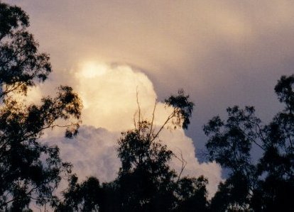
The photo above was
taken by John Woodbridge from Mt Crosby (Ipswich area) as the storm approached.
|
