|
Severe Thunderstorm over Gold Coast - October 16-17, 2000 There was a chance of thunderstorms on the edge of a SE�ly change that was moving up the coast during Monday night. However, it looked more likely for NE NSW. A few cells developed in NE NSW, including one on the border ranges just south of the Queensland border. This cell looked reasonably strong initially, but soon weakened as it drifted eastwards across the ranges. Reports of some nice lightning were coming in from the Gold Coast, and it had me on my toes! I wanted to see some lightning, but was unsure of the cell (which weakened to nearly shower status) would last. However, when the 13UTC radar image came in, I thought that the storm would begin to propagate northwards. Hopefully of this, I drove down on the M1 towards the Gold Coast, hopeful that I�d be right! I�d noticed some occasional lightning while driving down, however it generally remained fairly infrequent. None the less, I decided to keep going, and possibly watch some lightning out to sea if it didn�t continue to propagate northwards. I took the Smith St Mwy exit, and went down the Gold Coast Hwy, as to stick to the coast and try and get a better view of things. Unfortunately, the buildings did a good job in blocking things! However, lightning was beginning to get much more frequent, which was encouraging and had got me a little excited! I continued through the Gold Coast CBD and headed south, I got some very heavy rain in the CBD and most traffic was at a crawl because of this, fortunately there was not too much traffic to block the roads at this time of night (now nearly midnight). For the really bright flashes, I wound down the window in order to hear the thunder � this got me, and the inside of the car rather wet! But I heard some very nice loud rumbles. I probably continued for about 10-15mins towards the south, before deciding to turn around and had back north again. I wanted to get some more lightning and thunder, and hopefully get some on video tape. I soon got into some torrential rain heading back north, and was able to take some good footage!
The lightning was relatively infrequent (1-2 flashes a min), but the lightning there was, was blinding! It was sheet lightning, but they were CG�s. The reason why you couldn�t see the bolts was because the rain was so heavy, it obscured the actual bolt! Driving further north, coming back near the CBD rain was truly torrential, and there was some nice water on the road. Winds soon became rather gusty too! To the point that occasionally you could not have any water for half a second on the windscreen, and then get blasted twice as hard with water after the next gust had came through! This wasn�t bad for a border range thunderstorm I thought!!! I continued northwards, and still continued with torrential rain and gusty winds! All of the gutters were overflowing onto the road side, and occasionally a car went through it and sprayed up a nice little jet of water on the side!
I wanted to keep heading north, and try and get ahead of this cell, stop at a service station and get some video footage under shelter. But getting ahead of this propagating multicell was quite difficult while going through the CBD and urban areas! However, I eventually succeeded. However, I ended up driving under another forming cell that soon began to dump again as I went under it! There were absolutely huge drops, and visibility was so poor I nearly considered pulling over (I don�t pull over very easily!) This was probably a new updraft that had formed on the northern edge of the complex and had just started to dump its load as I proceeded under it.
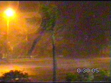
I soon got out of this, and was able to take shelter at a 24hr (deserted) BP service station just to the north of the Brisbane turnoff on the Gold Coast Hwy. I jumped out of the car with the video camera, and began filming rain and wind, which was quite impressive and the winds were quite strong! Probably reaching around 25kn initially at times.
There were several
nice flashes, however one in particular took the cake! While looking
in one direction and pointing the camera the other way, a terrific CG struck
just a couple of hundred metres away! I saw it, and visibly was one
of the best CG bolts I had ever seen! (It was so thick!!!)
The power went out simultaneously, and was followed closely by a loud crack
of thunder! Fortunately, 20 seconds later the power came back on,
however not all of the street lights came back on, which did ruin some
of my footage!
Click
here to listen to this CG! (Warning, high level coarse language)
Another
impressive CG! (Profanity free)
There was a fair
bit of nice lightning, and a couple of other nice CG�s nearby to follow
up! The gutters were well and truly overflowing on the side of the road, as 100+ rain rates continued. Every so often, I�d get a gust of wind come through that would soak me with rain, despite being under the service station roof! Towards the end, some very strong (gale force) winds came through, and literally pushed the water lying on the road down the street! It also completely drenched by and the video camera, and it was after this that I was forced to turn the video camera off as I was worried it�d get ruined by the rain! (There was water just dripping off it! Fortunately, it had no effect however I�ve invested in a rain jacket for it now!)
 I put the camera in the car and the service station attendant started yelling out to me �Mate, you�re insane! Get inside!!!� I was going to reject his offer before even stronger winds came through, and began to actually lift the service station ceiling! It was not tied down, it looked like panels, but it was enough for me to take shelter inside! However very shortly after this, the winds subsided as did the rain! It was now just light rain. I ran back out to the car, and took off, I wanted to see if there was any flash flooding, however I didn�t know the area very well, and wasn�t sure of where the creeks were, and at 12:30am it was difficult to go looking for them! I also had to be up at 6am the next morning, so decided to head back. I was treated to a nice light show as I headed back north and kept looking over my shoulder. And even back home I could see lightning in the distance. I watched radar closely for the next hour, and eventually decided that that was it for today�s action and headed off to bed at 2:30am. 40mm of rain was
recorded at Southport (just south of my position), looking at radar precipitation
occurred over this area for approximately 20 minutes. Hence this
puts this thunderstorm within the severe threshold.
Click
here for radar! (Courtesy of the Bureau of Meteorology)
The next day, in
between university classes etc, I saw quite a few nice (small) cells about.
I wasn�t able to get out until later that afternoon though (around 5pm),
but I wanted to get west of Brisbane and have a better look at some of
the cells! I was treated to a fairly nice sunset though, and it was
worth the effort :-) There were probably some hailstorms about looking
at radar, however no hail that I know of was reported.
 Wow � what a week!!!
While not widespread, the weather was certainly there if you went looking
for it!!!! I'm a happy chaser!!
Chase
Report by Anthony
Cornelius
|