|
WIDESPREAD RAIN
AND STORMS IN CENTRAL AND SOUTHERN QLD
A trough system is currently moving through the eastern states, with widespread showers, rain and storms developing ahead of it. A general area of cold upper level air over eastern Australia is aiding in the development of this activity, with storms developing around the clock. A very large cluster of rain and storms developed in SW QLD/NW NSW during the early hours of Wednesday morning, and persisted throughout the day and overnight, reaching the southern QLD coast early Thursday morning. Satellite picture observations revealed some interesting formations over inland western NSW during Wednesday afternoon. Below are 2 satellite pictures, the first (2:41pm) showing an impressive outflow boundary (west of the storm activity), and a strange 'tail like' feature on a cluster of storms on the QLD/NSW border. The second (4:48pm) shows storms forming along and near the outflow boundary. 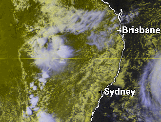 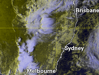
Rainfall totals in the Maranoa and Warrego district were generally under 10mm, with some of the highest totals being 11mm at Glenorie (Warrego), 9mm at Tamoo (Warrego) and 7mm at Cunnamulla (Warrego) and Dalmally (Maranoa). Station density in this district is far less than that of districts further east, and it is likely that heavier rain fell away from BOM guages. Rainfall totals on the Darling Downs from this activity, and also showers and storms that developed ahead of it overnight, were generally between 15 and 25mm. Some of the highest totals include Pittsworth (eastern Darling Downs) 23mm, Bowenville 22mm (eastern Darling Downs), Cambooya 20mm (eastern Darling Downs) and 17mm at Mt Driven (western Darling Downs). The cluster of activity reached Brisbane between 3 and 4am Thursday morning in the form of a rainband with isolated embedded storms. Rainfall totals around Brisbane and in the SE coast district were all under 20mm, with some of the highest totals being Kilcoy 18mm, Nambour and Malaney 17mm and Mt Gloirous and Kenilworth with 15mm. Widespread showers and storms also developed in central coastal QLD districts overnight Wednesday, with some moderate to heavy totals recorded to 9am Thursday. Some of the highest totals include a whopping 136mm at Middle Percy (Central Coast and Whitsundays), 74mm at St Lawrence (Central Coast and Whitsundays) and 31mm at Heron Island (Capricornia). Click here for a full list of rain totals for the 24 hours to 9am November 1.Early Thursday morning a very large storm developed in the northern Darling Downs, and tracked NE for many hours. This storm exhibited an overshoot on VIS satellite pictures over a period of 2 hours or more. The satellite pictures are shown below. The first is for 5:48am, the second 6:48am. 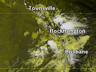 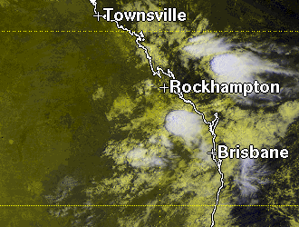 As it approached the coast it developed into a large area of heavy rain and storms, the most intense part of this crossing the coast between Bundaberg and Gladstone between 10:30 and 11am. This storm tracked through sparsely populated areas for most of its life, and to date there have been no reports of severe weather. And it wasn't even midday yet!Storms continued to develop in many areas in SE QLD and in the Capricornia district. Some of these were strong enough for the BOM to issue warnings. An example is shown below
Severe storms struck Rockhampton mid afternoon, bringing down trees and powerlines in the northern suburbs, backing out thousands. There were also severeal reports of hail. The Bureau of Meterology has confirmed the fact that 5 tornadoes were seen in the Capricornia district on this day. Click here to see a map showing the Queensland distrcit boundaries. Outflow boundaries were once again observed on the satellite pictures during the afternoon and evening, as seen on the two satellite pictures below. The first is for 4:48 EST, the second 6:30pm EST. 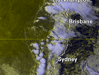  The activity in the SE coast district was limited to showers and areas of rain for most of the day. However, during the afternoon a solid band of thundery rain develop over northern parts, with an intense area of storms on the NW end of this band. Significant AWS observations A rain rate of 97.2mm/h was recorded at Heron Island at 3am Thursday morning. Heron Island also recorded 62.8mm of rain between 2:55pm and 5pm. Yeppoon recorded a rain rate of 52.8mm/h
at 4:39pm Thursday afternoon.
Report by Ben
Quinn
|