|
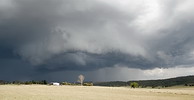
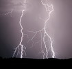
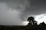
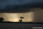
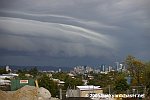
Friday, January 26, 2007 - Abundant low level moisture and a surface trough has
blessed SE QLD and NE NSW with several days of storms. Yesterdays storms produced some extremely heavy rain with
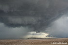
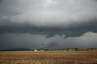
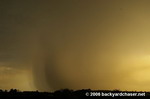
reports of up to 120mm in under an hour some areas S and SW of Brisbane. Today a tornado
was reported to the Bureau of Meteorology which led them to include the threat of tornadoes for a storm they were
warning for in their severe thunderstorm warning. The tornado was reported to have been sighted in the Laidley area, west of Brisbane, from a very isolated
but intense supercell that moved roughly north through the Lockyer and Brisbane Valley's after initiating
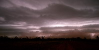
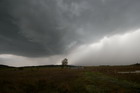
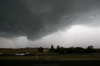
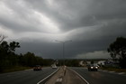
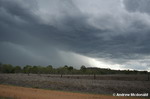
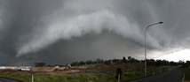
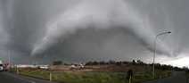
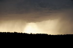
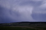
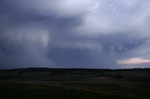
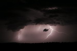
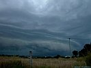
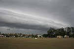
near Cunninghams Gap. The series of photos below was taken by Dave Secombe in the area 5-10km SE of Esk up to Toogoolawah, the same storm that
produced the tornado in the Laidley area. Unfortunately Dave didn't witness the tornado and at the moment there's no known photos
or footage of the tornado.


From Brisbane's Courier Mail this morning, describing the Laidley tornado :
Residents of Laidley, west of Ipswich, reported seeing a funnel-shaped cloud cut a swathe past the town shortly before 5pm, uprooting trees and sending debris flying. Vicki Mahone from the Laidley Hotel said it had put everyone on edge. "We were hammered," Ms Mahone said. "The place looks pretty messy, we've got trees down all over the place. "Every time I tried to close a window it would suck it back open again." While it may have only lasted a few minutes, the clean-up is expected to take days. Paramedics did not report any injuries. Bureau of Meteorology forecaster Tony Wedd said an experienced weather observer who lives in the area confirmed that it was a tornado.
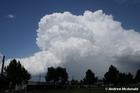
Friday and Saturday, January 12-13, 2007 - Two days of scattered storms on and west of
the NE NSW and SE QLD ranges and several chasers out and about to capture some of the action. The first two photos
below were taken by Ben Quinn at Tenterfield (NE NSW) and Warwick (SE QLD) respectively on Friday. The next 3 from
Inglewood on Saturday night, also by Ben Quinn. The next 5 were taken by Jason Rainforest on the central Downs in the
Pitsworth - Dalby area.


Chase reports and/or photo galleries : Jason Rainforest,
James Chambers, Marty Pouwelse, Michael Bath.
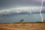
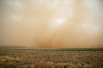
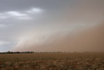
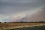
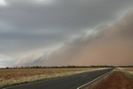
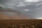
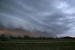
Monday, January 1, 2007 - Several days of heavy to severe storms through southern inland and western QLD has dumped much needed rain and lifted the level of several major creeks and rivers to the minor flooding classification. Ben Quinn
was chasing the area and encountered several severe storms. The series of photos below is of a line of storms which raised dust on the first day of the outbreak. The first photo was taken south of Cunnumulla, the next 6 between Cunnumulla and Charleville and the last
from Charleville itself.
Sunday, December 16, 2006 - Another major severe storm outbreak through SE QLD with widespread severe storms leaving a path of destruction. Chase reports are being
written and severe weather reports collated but for now a series of photos from Anthony Cornelius (first 4), Andrew McDonald (next 2) and Ben Quinn (last 4). Photos from Anthony and Andrew taken in the northern Downs and southern Burnett in the Oakey and Kingaroy area and
photos by Ben taken in the central and northern Wide Bay in the Tiaro and Childers area.


More photos and chase reports to be added during today (Sunday, December 17)
Chase reports and/or photo galleries : Andrew McDonald, Jules Just, Margarete Grubb, Jules Just, Marty Pouwelse.
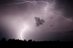
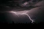
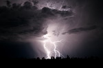
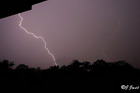
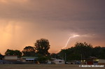
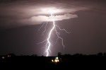
Sunday, December 3, 2006 - Some nice storms throughout SE QLD this afternoon with powerful
lightning at times. Heavy rain was also a feature, especially in the southern suburbs where up to 55mm has fallen. The first 2 images below were captured by the Redcliffe Webcam, the next is of
lightning striking the Q1 building on the Gold Coast, taken by
James Harris from Sydneystormchasers.com, the next by Dave Secombe in the southern suburbs. The next 4 were taken by Ben Quinn - the first
from Cambooya on the eastern Darling Downs, the next 2 from Marburg and the next from the western suburbs. The next photo was taken by Marty Pouwelse from the Cunningham Highway SW of Brisbane and the last photo was taken by Jules Just from Biggenden in the Wide Bay and Burnett.


Wednesday, November 29, 2006 - Very high based and rapidly moving storms developed through NE NSW and SE QLD today. The BoM issued STW's for several storms as they approached the coast and hail up to 3cm was reported from the western suburbs of Brisbane. The following photos were
taken in the greater Brisbane area by (in order of appearance) Dave Secombe, Margarette Grubb, Andrew McDonald, Whynot and Kate Lawrence. Also see a great little video clip by Whynot here.


Chase reports and/or photo galleries : Kaety, Margarete Grubb, Andrew McDonald, Jules Just, Marty Pouwelse, David Findlay, James Chambers, Stormy Spott.
Wednesday, November 15, 2006 - While some areas completely missed out
on todays storms there were still some very strong storms around. A supercell on the northern
end of the line that passed through Brisbane early afternoon damaged 54 buildings on the northside
according to an ABC news article
. Several supercells in the Wide Bay and Burnett produced hail up to cricket ball size!
The Gold Coast was also effected by at least one supercell (first two photos below taken by
James Chambers at Kingscliff). The next 2 were taken by Marty Pouwelse from Springwood -
a very close strike and an amazing effort to capture it during the day! The next photo was
taken by Andrew McDonald in the Wide Bay and Burnett, the next by David Findlay in the same area.
The next 2 were taken by Marty Pouwelse's partner at Eagle Farm (of the supercell on the
northern end of the Brisbane line). The next 2 were taken by Anthony Cornelius in the Wide
Bay and Burnett. The last 3 are of the supercell on the northern end of the line that moved
through Brisbane, taken from the Bruce Highway just south of Boondall by Ben Quinn.


Chase reports and/or photo galleries : Marty Pouwelse, James Chambers, David Findlay, Andrew McDonald, Stormy Spott, Margarette Grubb.
Monday, November 13, 2006 - Storms developed through much of NE NSW and inland areas of SE QLD this afternoon and continued to develop well into the evening, particulary in the Granite Belt district of SE QLD. Photos below taken
by Ben Quinn in the Warwick area.
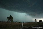
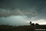
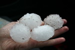
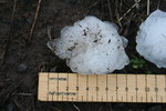
Wednesday, November 8, 2006 - A major severe storm outbreak in SE Qld today with several storms producing golf ball and larger sized hail. Energex recorded over 4000 lightning strikes through
coastal parts of SE QLD during the afternoon and as a result 24 000 people were without power at one stage. The first 2 photos below were taken by Jason Rainforest of a storm approaching the Gold Coast area and the next 4 were
taken by Andrew Macdonald in the Esk area - a massive storm which dropped 'gorilla' hail of up to 8.5cm (measured), smashing his windscreen in the process. The next photo by
Marty Pouwelse in the Boonah area, the next by Dave Secombe in the Peaks Crossing/Harrisville area and the last 2 by Anthony Cornelius in the same area.


Chase reports and/or photo galleries : Andrew McDonald, Marty Pouwelse.
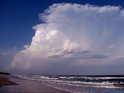
Saturday, November 4, 2006 - Some welcome (and much needed) rain throughout the SE quarter of Queensland over the last couple of days
with widespread totals of 25-50mm. Rain areas contracted to coastal areas during Saturday and storms developed inland in the clear air behind the cloudband
on the periphery of an upper low. Several chasers out and about and some spectacular photos to show for it. The first 3 photos below were taken
by Anthony Cornelius from Downunderchase.com near Kingaroy of a storm that prompted the BoM to issue an severe thunderstorm
warning. The next 2 photos were taken by Andrew McDonald in the Biggenden-Goomeri area. The next 2 were taken by David Findlay from
Qldstorms.com in the Kingaroy-Dalby area. The last 2 were taken by Jeff Higgins south of Dalby.


Chase reports and/or photo galleries : Marty Pouwelse, Andrew McDonald, David Findlay - photo gallery, chase report.
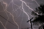
Wednesday, September 26, 2006 - A great start to the 2006 storm season today with scattered to widespread storms
forming throughout NE NSW and SE QLD. Several storms (or lines of) were severe and Gatton picked up a 91km/h (49 knots) wind gust and recorded
20.4 mm of rain in 12 minutes (102mm/h), 30.4mm in 18 minutes and 31.2mm in 20 minutes. Photos of the first line of storms are below, taken by various
people around the greater Brisbane area.


Also see a great timelapse of the line approaching Bracken Ridge here (3.75mb) and another video clip of a close lightning strike here (2.5mb).
Both videos taken by Whynot from the Weatherzone Forums.
Photos from left to right - Margaret Grubb, Bob Hartley, Dave Sercombe, Gumby, Anthony Cornelius, Marty Pouwelse, James Chambers, Julian.
Chase reports and/or photo galleries : Margerete Grubb, Marty Pouwelse, James Chambers, Julian, David Findlay,
Gumby.
|

