|
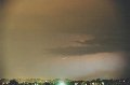
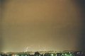
SHOWERS AND THUNDERSTORMS - DECEMBER 1, 2000 Showers and storms developed ahead of a trough system in NSW for many days prior to it reaching Brisbane, and all hopes were on similar activity in SE QLD. The activity that did develop was no-where near as strong, and was quite low topped, but during the afternoon in the setting sun it was quite photogenic! I was at Beaudesert around sunset, and photographed the following cell on the border ranges. Although it was low topped, the updrafts were quite spectacular!       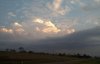 At the same time, a line of slightly higher topped storms was developing in a line NW/SE between Ipswich and the Gold Coast. As the sun set, it lit up the anvil beautifully. 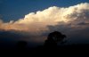 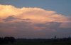 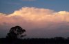  Steve Baynham, on the Gold Coast, managed to take a couple of lightning shots during the evening.
Report by Ben
Quinn
|