|
WET AND WINDY WEATHER IN CENTRAL AND SOUTHERN QUEENSlAND - HEAVY RAIN CAUSES STREAM RISES AND LOCAL FLOODING - OCTOBER 29 TO 31 An strong upper trough with embedded upper level low caused 2 surface lows to develop over QLD over a period of a few days - one in central/southern inland QLD overnight Sunday and during Monday, and a second developing off the central coast overnight Monday and tracking SE while deepening during Tuesday. Between the upper system and these 2 lows, a very large cloudband was sustained for several days, with widespread moderate to heavy falls in many parts of the state. Indications were that the low developing off the central QLD coast could bring severe weather to the coastline from about Gladstone south, and mid Monday afternoon the BOM issued a severe weather warning. TOP PRIORITY SEVERE WEATHER WARNING
However, there was some minor localised flooding in parts of the Sunshine Coast, north of Brisbane. I went out to survey this flooding during the early hours of Tuesday morning - my summary is below. After some very squally showers/periods of rain overnight (wind gusts up to 40 knots), and watching rain engulf the sunshine coast for hours at a time, i was confident of their being some localised flooding the next morning. I left home (Redcliffe) about 6:30am and headed for Nambour. When i got there, after driving through several periods of moderate rain and squally winds, it was quite obvious that a lot of rain had fallen. Most creeks had quite a fast fresh flowing through them, with some side roads cut, mainly from Paynter Creek. Once i arrived in Nambour i took some pictures of the following flooding in Petrie Creek - which was quite significant, but not really causing much concern other than flooding nearby parkland. 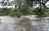 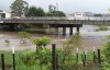 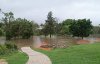 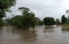 I continued north towards Yandina, taking a few pictures of the swolen South Maroochy River (first 2), then taking a detour towards Yappa Falls. When i got there the roar from the water was mind blowing! I took a couple of pictures of the normally small waterfall, which had been transformed into a giant washing machine! The roar was just a little too loud for this one waterfall, and i ventured along a narrow sideroad to see what else i could find ...... and BOOM there it was! The most magnificent spillway with water ROARING over the top, and smashing down into the creek bed below. A still picture and a few words makes it hard to convey the sound and sight of this, but it is the last thumbnail below anyway. 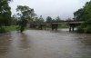 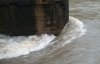 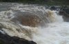 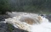 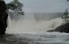
On the way home i heard of some flooding less than a km from my house back in Redcliffe! but by the time i got home the rain had eased and the flooding had subsided. Significant Observations Monday October 30 Gladstone AWS recorded a rain rate of 96mm/h at 9pm. Between 8:30pm and 9:07pm 42.4mm of rain was recorded. A breakup of this : Between 8:30pm and 8:49pm 18.4mm was recorded.Between 8:49pm and 9pm 17.2mm was recorded. Between 9pm and 9:07pm 7mm was recorded. Lady Eliot Island recorded a wind gust of 45 knots at 5:22pm, 50 knots at 5:24pm, 45 knots at 5:34pm and 46 knots at 6:26pm. Cape Moreton (NE of Brisbane) recorded several 10 minute mean wind gusts between 34 and 36 knots throughout the afternoon and evening. 1 minute mean wind gusts of up to 48 knots were observed via the realtime observations list. Payners creek near Nambour rose 1m in the space of an hour late in the evening. The Mary River at Churchill Street (location not known) rose 1.8m in the space of an hour around the same time. Tuesday October 30Cape Moreton (NE of Brisbane) recorded 10 minute mean wind gusts between 34 and 42 knots in the early hours of the morning and throughout the day. Once again, 1 minute mean wind gusts of up to 55 knots were observed via the realtime observations list. Nambour recorded a rain rate of 52.8mm/h at 4am. 58.2mm of rain was recorded between 1am and 7am, 40.2mm of that falling between after 4am. 74.4mm of rain was recorded at Toolara between 1am and 9am. 50mm of rain was
recorded at Redcliffe between 6:30am and 12pm (unofficial reading).
24 hour rainfall figures In the 24 hours to 9am Monday, October 30 The heaviest rain was in central coastal parts, with the highest total being 180mm at Byfield (east central coast). Some of the other totals include 141mm at Blue Mountain, 130mm at Sarina, 115mm at Doraville, and 109 at Yeppoon Heights - all in the east central coast. Heavy falls were also recorded in the Maranoa and Warrego, Darling Downs and Granite Belt, and the Wide Bay and Burnett districts. Some of the highest totals include 123mm at Gin Gin (south coast Curtis), 113mm at Roma (Maranoa). 108mm at Rosedale (south coast Curtis), 103mm at Wallumbilla (Maranoa), and dozens between 25 and 100mm. In the 24 hours to 9am Monday, October 30Heavy rain once again occured in the central coast districts, but also extended south to northern parts of the SE coast districts. Highest totals included Baroon Pocket Dam 235mm, Maleny 212mm, palmwoods 187mm, Nambour 174mm, Carmilla 172, Walla 171mm, Landsborough 162mm, Mt Larcom 160mm, Eumundi 164mm, Yandina 163mm, Pomona 139mm, Peachester 137mm, Gladstone 131mm, Bundaberg 129mm, and Monto 119mm.
Thanks to Laurier Wiliams for providing AWS obs on his site - Australian Weather News and Links - which were used in this report.
|