|
FUNNEL SIGHTED EARLY DECEMBER 1999 The two photos below were taken about 15 minutes apart. The first shows a lowering and prong. At the time I took this photo, I recall thinking that the bit of scud immediately to the right of the prong leading into the prong baselooked like a small funnel cloud. But a real funnel then developed from the prong which tightened up and elongated. At maximum extent it was a dark, clearly defined vertical 'elephants trunk' extending from the right edge of the lowering almost half-way to the ground. I was caught up on the phone watching this event unfold and hence missed the best development which I could see through the office window. The second photo shows the funnel as it was dissipating right after I got off the phone. The lowering seemed to get pulled into the funnel and has all but gone in the second photo. 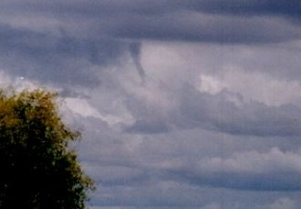 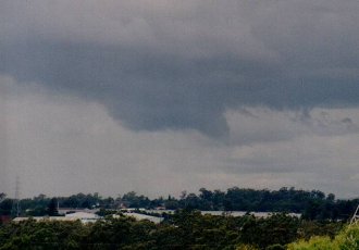 I put this event in the category of landspouts, as it occurred in a rather average E/W aligned Cu street, with tops at approx 5000m. No precipitation other than perhaps some light drizzle which is apparent to the left on the first photo, and no thunder or lightning, i.e., not a thunderstorm situation at all, although one could perhaps be forgiven for thinking otherwise looking at the first photo. The actual funnel cloud itself was clearly visible for about10mins which is a long time for this type of event. Report by John Woodbridge
|