

SEVERE STORMS
IN SE QLD AND NE NSW - OCTOBER 25, 2000
A surface trough
caused showers and storms to develop in SE QLD and NE NSW on this day.
When the trough produced a huge area of electrically active storms in the
Northern Tablelands district of NSW and southern inland QLD the day before,
things were looking great for storm activity in SE QLD the next day, providing
a rain band didn't develop. It did develop overnight, but thankfully
it moved off the coast early in the morning. Storms developed throughout
inland parts during the afternoon and evening, with several large and intense
cells. Hail up to 2cm in size was reported from Warwick, and winds
to 80-90km/h reported from just east of Boonah.
A tornado struck the town of Glastonsbury (west of Gympie) on this day. With any luck damage footage stills and more information will be added to this report at a later date. In the meantime, a brief summary of the damage is provided below, courtesy of Carl Smith.
Saw the footage of the damage on Ch 7 - unmistakably a tornado - wreckage strewn over quite an area along the path, with little left intact. The caravan was totalled and thrown a few hundred metres, along with a few sheds and other stuctures - caravan resident spoke about seeing his dog get sucked several hundred feet straight up.
Several people chased on this day, and links to their chase reports or summaries
are provided below.
Anthony
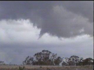
Cornelius bagged 2 wall clouds and
1 funnel! Click here
to see his report and pictures.
Jason
Rainforest, Ben
Quinn and Ross
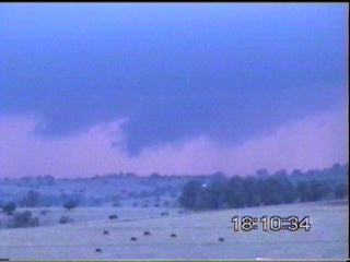
Portas chased on the eastern Darling
Downs, and intercepted an awesome (and probably severe) storm SW of Warwick
late in the afternoon. Another severe storm was experienced just
east of Boonah on the way back to Brisbane. A chased report will
be compiled in the next few days - in the meantime check out these pictures:
2 MPEG videos are also available.
The first (340k) shows some rapidly moving rain streaks (which may be a
little hard to see on some monitors) and sucd movment along a developing
gust front. The second (1.34mb) is a pan of the storm we intercepted
SW of Warwick.
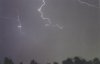
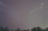
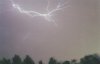
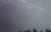
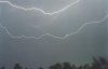
Steve Baynham took the following lightning pictures from the Gold Coast during the evening.
A summary of the events in Warwick is provide
below, courtesy of Adam
Cole.
After receiving 20 mm of rain
in the early hours of the morning, my first inclination that there was
definitely going to be a storm was at about 1 pm. From here I quickly moved
to the Warwick lookout which has a great 360 degree view. Perfect for spotting
storms. With my trusty camera and notepad, I arrived at 1.15pm A heavy
shower that had passed over Warwick at about 12.50 pm was now building
on the ranges and I noticed another storm to the South which as I arrived,
may have had a decent funnel. It disappeared over the next 10 mins and
was obscured by a hill, but I still took a photo and watched nature unfurl.
I also noted a developing system to the North West And wind seemed to be
moving from the NW to SE, sometimes fairly strong.
1.30PM
At this stage I could see 4 main areas
of development, all having rainfall visible and 2 having anvils. The storm
to the NW was now NNW and had reasonable development. Also noted was the
significant build up in the west, but obscured by fast moving lower level
clouds.
1.45PM
Significant build up to the NE occurred
with pretty much more distinct development seen. After all morning being
overcast, now there was lots of blue sky and more defined build up. Things
were looking good with Nth storm producing good anvil, but this system
stabilsed for a time. Unfortunately I had to go back into town and I awaited
to see what would happen.
By 2PM build up was been seen everywhere.
And at 3pm a large area of anvil was seen starting to move towards Warwick.
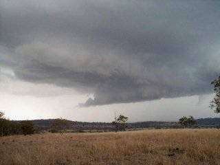
At 4pm the storm was coming into view and it hit at 4.30PM. Two definite
wall clouds were seen side by side, but no rotation and lasting only short
time. However, storm produced torrential rain, gale force winds and hail
in places. Reports of hail up and above 2cm but mostly pea sized. Wind
and rain combined made this storm bad, if not severe. 15mm or rain was
recorded at my home, however, I may have seen more at the other side of
town, closer to 20 mm in 15 mins. Rain rate at one stage was over 100mm/hr
and ground water accumulated very quickly and lasted for sometime. Some
spectacular lightning was observed, a lot of being massive CG's and thunder
was intense. Storm seemed to be still growing in strength as it approached
and passed over.
Over all, a heap of photos taken and an
early evening lightning show was to follow with some beautiful bolts seen.
NE NSW also had a great day, with a
MASSIVE line of storms developing mid afternoon. A summary of the
events is provided below courtesy of Michael Bath (co-webmaster of Australian
Severe Weather).
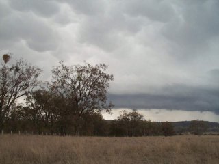
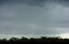
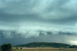
What an afternoon! As well as
SE QLD firing, NE NSW has also. The most spectacular shelf cloud formation
spread in slowly from the west after forming SW of Lismore. Awesome laminar
banding along a 20-30km long gust front, lowerings and swirling scuds touching
the ground, intense precipitation and lightning, and the beautiful green
tinge in the boiling updrafts. I suspect some areas have been hit with
large hail, but awaiting reports. I took off just before the precipitation
hit the area around 5.30pm
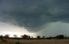
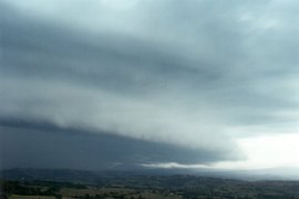
Another large shelf cloud developed towards
dusk and has passed through during the past hour or so. CGs and CCs every
second or two and some moderate rain, but no hail or significant winds
in it.
Michael has a report up on his website for this day. Click here or on the thumbnails above to see it.
|
