Main Menu Photo Gallery Video Footage Storm Chasing Recent Events Current Weather Forecasts Webcams Links About Us Severe Weather

Archive of Reports Current Reports

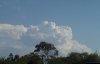
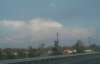
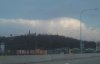
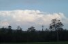
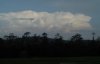
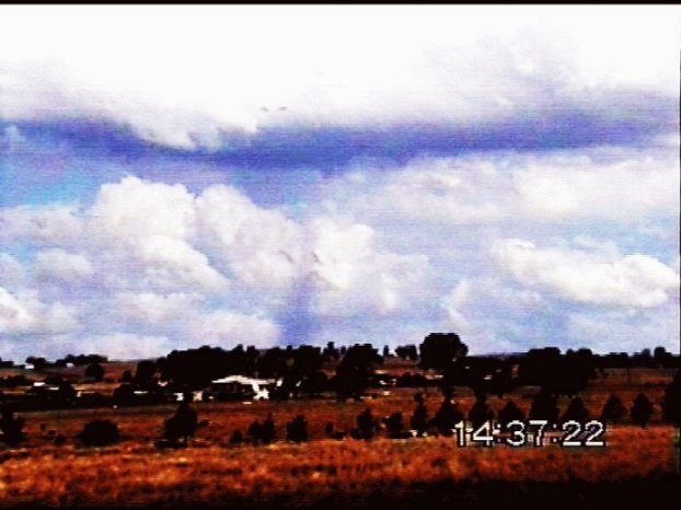
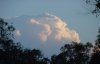
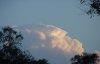
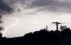
WILD STORMS LASH SE QLD AND NE NSW - OCTOBER 26, 2000

A combination between a surface and upper level trough caused widespread showers and storms to develop over much of NE NSW and SE QLD during the afternoon and overnight.  The daytime activity was mainly confined NE NSW and southern inland SE QLD.  I managed to get a few pictures :

The first picture shows some lovely congestus updrafts with a Cb in the background, taken from southern Brisbane.  The next 2 pictures (taken 5 mins apart) show the evolution of an overshoot on a storm off the NE NSW coast.  Sorry about the quality of these two, they were taken from inside the car while driving, and with rain between myself and the storm.  The next two (taken 10 mins apart) show the same storm about half an hour later 

October 26, 2000 - Taken by Ben QuinnOctober 26, 2000 - Taken by Ben QuinnOctober 26, 2000 - Taken by Ben QuinnOctober 26, 2000 - Taken by Ben QuinnOctober 26, 2000 - Taken by Ben Quinn

A TORNADO was videod by Anthony Cornelius SW of Brisbane on this day.


Click on the above thumnail to see his chase report for this day, and a report on the tornado


During the late afternoon a line of storms 
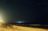
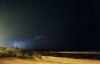
in the northern Rivers district of NSW began to intensify both visually and on radar,  Before long a very strong storm had developed, and was now moving NE towards the Gold Coast.  The Bureau of Meteorology soon issued a severe thunderstorm warning, warning of the possibility of strong winds, hail and heavy rain. Visually from Redcliffe, this storm was quite spectacular with boiling updrafts punching up into a sacer shaped anvil!  A large overshooted lasted over half an hour!.  It's yet to be confirmed, but it's quite possible this storm was a supercell.  Jason Rainforest managed to get some pictures of this cell as it was developing, which can be seen to the left and right.

Lightning photos are now starting to filter in - check out the one below taken by Ross Portas (first one) and Andrew Maben.


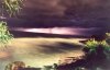
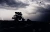
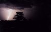
These storms caused considerable damage in parts of NE NSW.  The following summary is courtesy of Michael Bath (co-webmaster of Australian Severe Weather) who lives just ENE of Lismore.

The storms that smashed through my area last night from 7pm, has managed to shift a 5000 gallon water tank 500 metres from where it was, smashing a line of trees and ending up in my neighbours property which is below us. A Large tree has been snapped off about 2 metres above the ground as well. We have some minor tree damage, but most of ours are recent plantings.  I haven't been out to check the local streets for any other damage. I estimate the gusts to around 60 knots. We had water enter our front (N facing) rooms forced in through sliding doors, and some managed to get in from the top of a bedroom window.

We had 15mm in about 10 mins with rain coming in horizontally from the NW. Based on the erosion and scouring, I'd say a lot more rain actually fell but flew over the top of my gauge - more like 30mm fell.

Then came the lightning - amazing strobing lightning for hours as the storms moved out over the coast and also up to the border ranges and the Gold Coast. I watched and photographed till about 10pm when it got a bit far away


Michael has a report on this day on his website - click here to see it.


The storm continued to move NE, crossing the coast just south of Coolangatta.  A summary of the events in Burleigh is provided below courtesy of Carl Smith.

About 7:30pm AEST it looked like we were going to cop it - lightning flashing almost continuously in a band from S to W of us - ABC 4QR just about drowned by the near continuous static - really couldn't hear the program through it.

At 7:50, the wind had started, the lightning was getting close, the thunder was quite loud, with no quiet breaks, and sporadic spots of rain were falling.

By 8pm, the storm was starting to move overhead, lightning was flashing nearly continuously in every direction, and for the next 20 minutes, we were subjected to a very spectacular display, with periods of torrential rain. The were many close GC hits, including one that I think hit a eucalyptus tree right next to the house - just about jumped through the roof when that one hit - no gap between the brilliant flash and the tremendous crash. There were many other close CG strikes within a 3-400 metres of the house - very loud crashes within a second or so of the flash - I saw several hit in the park adjoining the house, and there were many more spectacular CC complex zig-zag bolts, some filling much of the sky visible from the doorway. There were few moments darkness between the frequent flashes.

By 8:30pm the storm had moved out over the sea, but was still putting on a good show.

Certainly one of the better storms I have seen in a while!


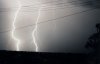
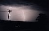
While this storm was approaching the Gold Coast, another strong line of activity was developing further NW, SW of Beaudesert.  A cell on the northern edge of this line had an obvious bow echo on radar at one stage, and it's quite possible that it contained severe winds.  From Redcliffe, the lightning in this line was quite active, with a flash every 3-4 seconds, increasing to 1 every 1-2 seconds at times.  The lightning was also lighting up some very large and magnificent mammatus.  This activity eventually moved off the coast between the southern suburbs of Brisbane and the Gold Coast.

More storms began to develop on the eastern Darling Downs, moving quite swiftly ENE.  This activity soon became quite lightning active too, with flashes every 2-4 seconds seen from Redcliffe.  Before long a line of activity developed, and moved E/NE towards the coast.

The lightning to the west was becoming more fequent and powerfull, with many strikes pulsing/strobing.  I decided to head out towards Strathpine.  As i drove west the lightning really started to increase, with Cg's now visible, and a flash rate of about 1 per second.  I drove through Kallangur, and then NW towards Daybora.  I stopped at several lookouts along the way to observe the many Cg's and strong sheet lightning - at times there were Cg's every couple of seconds!  I pottered around this area for half an hour or so, then decided to head back to Redcliffe.

On the way back i observed many close Cg's and some extremely bright in cloud lightning.  I ended up making it to the northern end of Redcliffe through the heavy rain, and sat there for an hour or so observing the countless Cg's and anvil crawlers. >It was at this point that i saw the most amazing thing! To my NW, possibly around the Beerburrum area, i observed 4-5 dome shaped flashes on the horizon.  These occured a few seconds after a lightning strike, and my first thought was "transformer or sub station hit" - but the thing is, each flash was a different colour! A mix of orange, green and white colours!  If anyone has any ideas of what this could have been, please email me.


Report by Ben Quinn