|
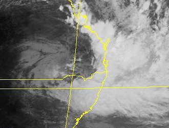
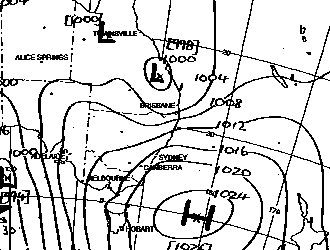
WHEN IT RAINS, IT POURS - TORRENTIAL RAIN AND SEVERE WINDS BATTER SE QLD AND NE NSW - FEBRUARY 1 AND 2, 2001 The forecast charts leading up to this event were ominous, indicating a possible/almost likely major flood event for parts of the central east coast of Australia. The system comprised of a strong upper level trough which would amplify into eastern Australia on Wednesday (Jan 31), move north into SE QLD and develop into a mid - upper level low. At the same time, a high was moving into the Tasman sea. The pressure gradeint between this high and the low in SE QLD fed strong, moisture laden onshore winds into an area of convergence on the SE side of this low. Coupled with orographic lift created by the NE NSW/SE QLD ranges, prolonged heavy - torrential rain was the result. NE NSW was the first district to experience heavy rain, with a solid rainband developing on Wednesday morning and persisting through the day and into the night. This rain gradually developed further north during the late afternoon and evening, with the heaviest rain areas in SE QLD being in central and northern parts of the SE coast district. Totals for the 24 hours to 9am Thursday in SE QLD were generally between 25 and 125mm, with the higest falls N and NW of Brisbane in the Sunshine Coast Hinterland Totals for the 24 hours to 9am Thursday in NE NSW were generally between 25 and 180mm, with the heaviest falls in the Northern Rivers district. The rain began contracting
to southern parts of the SE coast district on Thursday morning, with only Rain areas remained isolated for the rest of the day, but soon a major change to the system would signal the start of the heaviest rain. By evening, the rain began moving in from the NE, as opposed to W or NW previously. Rain coming in from this direction is one of, if not the biggest producers of high rainfall in the SE coast district. Winds began to steadily
increase around the district, and the BOM issued a severe weather warning.
Over 15 000 people in Brisbane the Gold and Sunshine coasts were blacked out overnight, with power not restored to some areas until as late as Friday afternoon. The highest wind gust recorded was 120km/h at Cape Moreton during the early hours of Friday. Many of those who braved the cyclonic like conditions were hampered by local and flash flooding which was reported from many areas of Brisbane and the Gold Coast. Several motorists had to be rescued from their cars after becoming trapped in floodwaters - one man had to be rescued from a Kenmore creek after his car was swept off a floodway. Waves of up to 5m pounded Gold Coast beaches causing considerable erision and sending walls of foam onto nearby streets. In NE NSW, a severe
storm tore through the town of Tenterfield
on Thursday night with winds of up to 130km/h damaging roofs and bringing
down scores of trees. SES volunteers recieved up to 150 calls for
help.
SE QLD Rainfall totals in the 24 hours to 9am February 2 In Brisbane totals ranged from 80 to 150mm, with much higher totals on the ranges S, W and NW of the city. Some of the highest totals were Springbrook 352mm, Natural Bridge 320mm, Hinze Dam 295mm, Mt Nebo 288mm, Mt Glorious 254mm, Canungra 252mm, Mt Nebo 229mm, Mt Mee 191mm, Nerang 188mm, Darlington 186mm, Miami 164mm, Bromfleet 159mm, Kelvin Grove 150mm, Ashgrove 149mm, Toombul 135mm and Gold Coast Seaway 123mm. (click here
to search for the above locations in Austligs place finder)
Northern Rivers (NE NSW) Rainfall totals in the 24 hours to 9am February 2 Some of the highest totals in the Northern Rivers district of NE NSW were Mullumbimby 349mm, Murwillumbah 275, Tweed Heads 254mm, Alstonville 244mm, Casino 215mm, Ballina 206mm, Lismore 195mm and Nimbin 174mm. (click here
to search for the above locations in Austligs place finder).
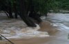
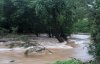
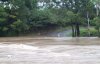
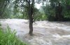
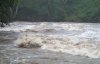
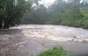
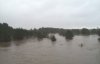
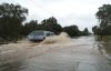
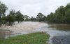
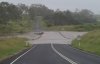
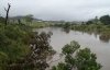
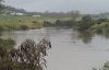
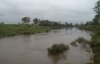
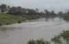
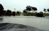
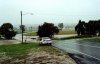
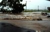
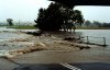
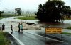
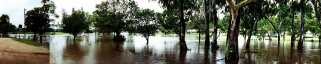
The result of such heavy rain was of course widespread flooding. In NE NSW, flooding led the government to declare the region a natural disaster region at 2pm Friday afternoon. The town of Lismore was inundated with water, up to 3m deep in the CBD. Over 200 business and houses were evacuated as the Richmond River began rising to what would be it's highest peak in over 10 years. The Pacific Highway was closed betwen Murwillumbah and the QLD border, with people being diverted via the New England highway. In SE QLD the flooding was on a much smaller scale, however numerous rivers and local creeks went into minor or moderate flooding, and even major flooding in Lockyer Ck . I photographed the flooding around my local area early Friday morning. The majority of the photos below are of the South Pine River .
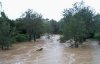
The mighty Mary River was also sent into flood, reaching a peak of around 9m at Gympie on Sunday February 4. My dad was able to get some photos of this flooding on the way to his property at Kilkivan. The river height at this stage was around the 8m mark.
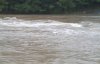
Adam Cole took the following photos of floodwater making its way down the Condamine River on February 4. All photos are taken from the Warwick area.
One thing to note, albeit for the more advanced weather enthusiasts, is the north-west movement of the upper low after it developed in SE QLD. This is quite a rare movement for upper level systems, infact during the 3 years i've been forecasting, i've never seen anything quite like it.
Many areas of NE NSW have been inundated with flood waters, with the Commonwealth Government declaring the region a natural disaster area. Over 15 000 homes were blacked out in Brisbane, the Gold and Sunshine Coasts as severe winds brought down trees over power lines. The strongest wind gust recorded was 120km/h at Cape Moreton during the early hours of Friday, February 2. Gold Coast SES received 100 requests for assistance (to 9am Friday), mainly from water leaking into houses as the rain bucketed down, and Brisbane SES received around 50 requests. Severe winds also caused damage at Mt Glorious and at elevated places on the eastern Darling Downs. Over a dozen roads were cut around the Gold Coast during Friday due to flooding. There were many reports of local and flash flooding throughout coastal parts overnight Friday as the rain was falling.
Report
by Ben
Quinn
|
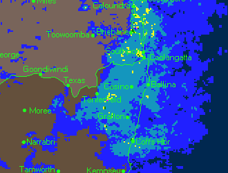
 showers
persisting in other areas. However, by late morning a band of rain
and storms began developing over inland areas. This band of activity
moved through coastal parts during the early afternoon with heavy rain,
dumping over 50mm in an hour in some places! Wind gusts of almost 80km/h
were recorded in the bayside suburb or
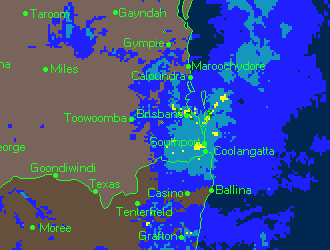
showers
persisting in other areas. However, by late morning a band of rain
and storms began developing over inland areas. This band of activity
moved through coastal parts during the early afternoon with heavy rain,
dumping over 50mm in an hour in some places! Wind gusts of almost 80km/h
were recorded in the bayside suburb or