
 SEVERE THUNDERSTORMS
IN THE SE QUARTER OF QUEENSLAND - JANUARY 1, 2000
The first day of
the new millenium was setting up to be a fantastic day to chase, with shear
very supportive of supercells, and yet another rare situation where right
movers would be favoured. A strong upper level trough was situated
over us, and the jet was very favourable. Despite the SE'ly winds,
the emperatures and moisture levels were still going to reach fairly high
levels for the cold air aloft. Unfortunately, I was unable to chase
due to relatives from overseas staying with us for the week end, but I
certainly was able to get a glimpse of a few interesting features!
Thunderstorms were
developing early that day, especially in the Wide Bay Burnett district.
Thunderstorms were already reaching maximum intensity on radar by 11am!
By 12:34pm, a top priority severe thunderstorm warning was in effect for
all of the south-east coast district, and wide bay & burnett districts,
with thunderstorms with large hail and severe wind squalls already being
reported in the Gympie to Maryborough region! Very soon, explosive
development took place in the Wide Bay & Burnett, as well as the Capricornia
districts. Severe thunderstorm advices were also being issued for
the northern NSW district - by middle of the afternoon, the BoM had issued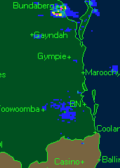 warnings/advices
for nearly the entire central eastern coast! Most of the thuderstorms
developed to the north of Brisbane, but also soon started developing in
the south-east district. I was out and about showing relatives dad's
property, and showing them through the Brisbane Valley to the Sunshine
Coast. I saw a few of the thunderstorms developing, one had an interesting
base that was already showing signs of rotation as a TCU! We had
to hurry along though, but very soon I did notice some explosive development
to my south, and the west. To my north there was anvil cirrus littering
the sky, it was getting quite exciting, as there was a good chance that
we might run into one of the cells that were forming to the north, in the
Brisbane valley! We didn't actually go through a cell, but we came
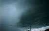
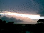
quite close to what I believed to have been a spectacular supercell! Unfortunately,
the Brisbane Valley is full of hills and forests - so any view of this
cell I ever had was always severely limited, but my first glimpse of it
after I saw it develop was very spectacular! Strong updrafts on the
back, with a backshearing anvil & overshooting top, with a collar cloud
around it!!! I had never seen a collar cloud, but from my experience
of what I have read and been told, it nearly always indicates rotation
in a thunderstorm. The cell basically screamed 'supercell' to myself.
Unfortunately, there was no time to grab the camera out as dad sped along
the highway. I did however get a few more glimpses of it, and I have
video footage of it, but without the collar cloud. It still looked
quite spectacular, there's also what appears to be a possible very shallow
wall cloud under the main updraft of the RFB in the video footage.
The cell showed obvious signs of inflow too. Going through my video
footage, there does appear to be a funnel cloud in some of it - but looking
at it closely, this is most probably a very curved hail shaft! At
times, it does look quite convincing - but a hail shaft would be the most
likely, considering the cell did exhibit a fair amount of maximum intensity
on radar, the air was very cold, and generally a lot of thunderstorms that
form in SE winds here contain hail. warnings/advices
for nearly the entire central eastern coast! Most of the thuderstorms
developed to the north of Brisbane, but also soon started developing in
the south-east district. I was out and about showing relatives dad's
property, and showing them through the Brisbane Valley to the Sunshine
Coast. I saw a few of the thunderstorms developing, one had an interesting
base that was already showing signs of rotation as a TCU! We had
to hurry along though, but very soon I did notice some explosive development
to my south, and the west. To my north there was anvil cirrus littering
the sky, it was getting quite exciting, as there was a good chance that
we might run into one of the cells that were forming to the north, in the
Brisbane valley! We didn't actually go through a cell, but we came
quite close to what I believed to have been a spectacular supercell! Unfortunately,
the Brisbane Valley is full of hills and forests - so any view of this
cell I ever had was always severely limited, but my first glimpse of it
after I saw it develop was very spectacular! Strong updrafts on the
back, with a backshearing anvil & overshooting top, with a collar cloud
around it!!! I had never seen a collar cloud, but from my experience
of what I have read and been told, it nearly always indicates rotation
in a thunderstorm. The cell basically screamed 'supercell' to myself.
Unfortunately, there was no time to grab the camera out as dad sped along
the highway. I did however get a few more glimpses of it, and I have
video footage of it, but without the collar cloud. It still looked
quite spectacular, there's also what appears to be a possible very shallow
wall cloud under the main updraft of the RFB in the video footage.
The cell showed obvious signs of inflow too. Going through my video
footage, there does appear to be a funnel cloud in some of it - but looking
at it closely, this is most probably a very curved hail shaft! At
times, it does look quite convincing - but a hail shaft would be the most
likely, considering the cell did exhibit a fair amount of maximum intensity
on radar, the air was very cold, and generally a lot of thunderstorms that
form in SE winds here contain hail.
Unfortunately, as
we travelled further north, and passed it to our east, it began to collapse,
but gave a very nice little double rainbow in the precipitation shafts!
Interestingly enough, this cell actually split about 120km north of us,
and than moved to the right of all the other cells, with the left mover
dying quite quickly. This certainly seems to suggest a supercellular
thunderstorm.
There were reports
of hail up to 4-5cm between Gympie and Bundaberg, and severe wind squalls
with some houses losing their roofs. All in all, it was a fantastic
day, and it would have been great to have been chasing properly, but unfortunately
that can't alwaysn happen, and I'm very appreciative and happy with what
I saw!
Adam
Cole has provided the following summary
of the day at Warwick.
Well, what
an awesome day. Had family up for the new year and it was unbearbly hot
and humid on this day. I decided to go golfing with the relations and while
out on the golf cours kept and eye on the sky. The Warwick golf course
has a great view of the east on the upper part of the course and as playing
i was watching one particular updraft go up, that lookied strong. This
updraft was almost right above my head. My cousin asked what will that
do, and i said in about 30 mins it'll be a storm. I was absolutley right.
30 mins later, a flash of lightning to our east (as this is where it had
moved) and 7 secs later a nice big rumble of thunder. A little disconcerting
on the golf course though and i couldn't wait to get back home to check
the BOM's warnings.
Got home a little
after one pm and it was HOT!, But also there was a Severe storm warning
out for the Cunninghams Gap area. That was the storm i saw develope on
the golf course :-) Looking on radar it is the strm that starts at red
east of Warwick.
So after this, i
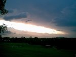
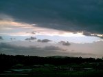
decided to take a pictorial history of the sky at regular intervals.
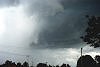
The initial photos
are of the sky to the north and you can see the first storm tnat goes JUST
east of Warwick with the huge updrafts. In the background is the anvil
of that storm that hits us. However at this time, i didn't realise that
this was the direction the Thunderstorm was to come from. Heard a few rumbles
of thunder from the cell now south of us and the updrafts looked real good.
But still no sign of a storm for us. All i could think was Bugger, we missed
out again.
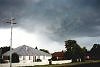
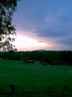
20 mins later it
went a bit dark, so i walked out the front door. GET ME MY CAMERA, QUICK!!!!
And i photographed this storm as it approached. And as you can see by the
photos, she was a beast!! I mean, WOW. The temp as the storm appraoches
plummetted and i knew there was hail for sure, but unforetunately, it was
to go a few blocks east of me. Some nice wind gusts as the storm hit were
very cold and some rain, but not much.
Then to top off the
perfect day, another massive storm then aproached from the WSW first noticed
about 8pm witht he lightning. Watched it from the front yard for 45mins
until it got close, then went inside and got to a nice window to watch
a great lightning show. Several very close strikes and some more torrential
rain and it was described by my uncle who grew up in Warwick as the classic
Warwick Thunderstorm.
Rainfall totals for
the day totalled only 17mm, with approx 3 mm from the first storm and 14mm
from the second in about 15mins. Rainfall rates were 100+mm/hr for both
storms at times.
This day was probably
one of the best for a while in Warwick as of recent times as for the last
month we have had 1 storm and several days of rain, but now we start the
new year with a bang!
Ben
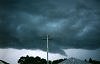
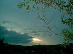
Quinn also took the following photos
of the anvil from a very large and strong storm to the NW of Brisbane late
in the afternoon.
|