|
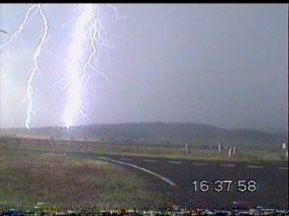
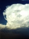
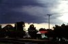
SEVERE HAILSTORMS - DECEMBER 12, 2000 A combination between a surface trough and a broad area of cold upper level air over SE Australia caused showers and storms to develop over eastern inland parts of SE QLD and NSW on this day. Strong vertical development could be seen to the west of Brisbane from late morning onwards, and by early afternoon a line of active storms developed in a line from roughly Crows nest, south to Toowoomba. Some cells in this line maintained very high intensities on radar for extended periods, however, to date, there have been no reports of severe weather in this area. Strong activity also developed on the border ranges during the afternoon, with an extremely intense cluster of activity developing SE of Warwick, moving N then propergating NW. Several periods of hail (up to 3cm's in size) was reported from Mt Marshall (near Allora) by an observer, along with severe winds, which brought down trees and powerlines. Brisbane storm chaser Anthony Cornelius and visiting Victorian chaser Paul Yole experienced 3-4cm hail, 90-100km/h winds and witnessed a funnel cloud from this storm!
Click here to read their chase report
During this time cells were noted W of this Dalby and also a severe one near Warwick. This proved to have max lightning from about 3PM to 5PM. Lightning basically continual to South (Stanthorpe & Tenterfield)
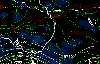
Radar
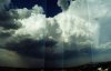
Showed storms starting crowes nest with max intensities moving north Kingaroy. Unusual item about Warwick storm was came from SE of Warwick and moved in an anti clockwise direcion That is it moved to north of Warwick after gaining what storm material had been near Stanthorpe and rapidly intensified and continued to grow as it went through north of Warwick and then seemed to back track to the immeadiate west of Warwick. I also observewd this phenomen with continualally changing anvil direction and watching the storm turn around.
I don't believe I have ever seen this happen before. Take note that the storm has a bow effect but that in proceeding to this effect the Storm moved West and then SW after initial movement was NW. After disappaiting, there was contiued movement to wards north West but also to North east, possibly resulting in the quick way this storm died.
Obserations
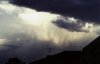
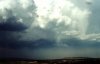
Seemed to be very hazy when this storm was at its max intensity, however, this may have been dust created by the storm. Significant winds were observed in Warwick as the storm turned and possibly a tornado was on the ground, probably large to account for the amount of dust that seemed to be in the air at the time to the direction of the storm as observed from Warwick. This tornado would have gone through sparesly populated areas of the Cunningham's gap area and on towards Allora. Wall clouds were just able to be made out from Warwick through the dust, with several possible lowerings sighted but extremely unphotogenic due to dust. These were to the NE.
A highly unusual day. Summary of significant
observations
Hail 3-4cm's in size and severe winds to
100km/h were reported from storm chasers Anthony
Cornelius and Paul
Yole near Mt Marshall.
An unoffical report of over 110mm from this storm was reported from the same area.
3 seperate periods of hail (up to 3cm's)
in size was reported from Mt Marshal (near Allora), along with 45mm of
rain from the storm.
A house at Tara (just NW of Dalby) on the
Darling Downs losts it's roof in a severe storm late in the afternoon.
Some hail was reported in Toowoomba around
2:30pm.
Toowoomba AWS also recorded a rain rate
of 75.6mm/h at 2:54pm, with 18mm of rain in 33 minutes.
Rainfall in the 24 hours to 9am December
13 was significant, with many stations reporting falls in excess of 25mm.
The highest falls were Maryvale 44mm, Mount Binga 37, Oakington 32, Toowoomba
32, Cooby Creek Dam 26, Mt Kynoch 25, Waverley 22, Crows Nest 22 and Dalby
18mm.
Data for this
day
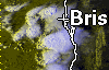
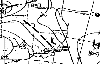
In order of appearance : Brisbane
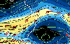
local scale radar event loop (312k), lightning tracker loop (150k), VIS
satellite picture (190k), MSLP chart (20k), 500mb analysis (50k), 200mb
analysis (54k).
Credits Thanks to Adam Cole for providing a lot of the information used in this report. Also thanks to Anthony Cornelius and Paul Yole for various information. Thanks to the Toowoomba SES for providing
information on the severe storm at Tara.
Report by Ben
Quinn
|