
 SHOWERS AND THUNDERSTORMS
IN COASTAL AREAS OF SE QLD - AUGUST 23, 2000
A combination between
a surface and upper level trough caused showers and thunderstorms to develop
in coastal areas of SE QLD Wednesday, August 23.
Storms began developing
in the northern suburbs by late morning/early afternoon, with storms developing
and moving over the same area for several hours. They were moving
incredibly fast and were very hard to chase, but i did manage to take photos
as they moved off the coast.
Click here
or on the above stills to go to my chase report
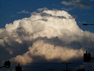
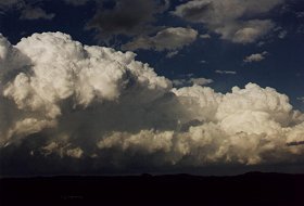
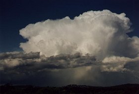
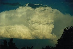
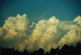
Mid afternoon a storm
moved through the NW and southern suburbs of Brisbane dumping hail and
heavy rain in many suburbs. As this storm moved offshore it took
on a spectacular appearance.
 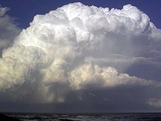
First photo taken by Jason
Rainforest from Pimpama, second photo taken
by Ross
Portas from the Gold Coast
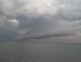
By evening most storms had moved offshore,
and a spectacular lightning show was to follow.
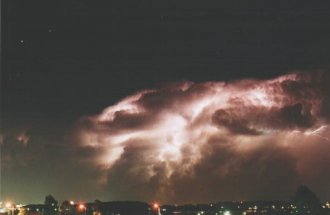 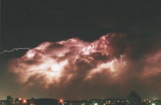
Photos taken by Steve
Baynham. Click on the thumbnails for a full size version.
There were reports
of severe weather. A possible Tornado was sighted from
the Sunshine Coast. The following information is courtesy of Andrew
McDonald from MSC
- whos grandparents live at Moffats beach.
A funnel was sighted at around
3:30pm from the 'back end of a thunderstorm'. The funnel slowly extended
towards the ground and appeared to be on the ground for a period of around
15 minutes. The Tornado was 20-30km's NW of the observers, probably
somewhere in the Cooroy - Gympie - Brooloo area.
Flash flooding
reported on Rochedale road and branches and a tree down on Mt Cotton road.
There were also reports of hail in numerous suburbs throughout Brisbane,
including hail from 1.5-2cm at The Gap from Narelle
Bowmaker.
The following summary
is from Anthony
Cornelius.
What a great
day it was! (Except for the fact that I was at work for most of it).
I went to work early so I could try and leave work early if I had to.
We had not one, but two hailstorms at work! Once at 1:50pm (only very
small and brief), and again at 2:20pm. We had strong winds (30kn)
with heavy rain initially, and then the winds died off (we have a tin roof
at the office), and then I suddenly heard sone "tings" and yelled "THAT'S
HAIL!!!" as I flew out the door for the millionth time (much to my boss'
displeasure) with the video camera. In the background, my boss was
telling me how hopeless I was for saying she didn't have to move her car!
She didn't understand that pea sized hail wouldn't do anything!
Anyway, 5mins later,
I wrapped it up (finally) and left - the storms were moving to the SE to
fast, so I headed to Rochedale Rd as there was a nice little lookout there
to the east, and it'd put me in a better position if anything
else developed. There was a lot of water on the road near work, and
some on Logan Rd - flash flooding on Rochedale Rd! Branches and stuff down
on Logan Rd (northbound), and also a tree down on Mt Cotton Rd.
I had to eventually
turn back and head for uni - I took the SE Fwy into the city to goto uni.
On the way I was watching some AWESOME updrafts on the Cb's out to sea,
and decided that a stop in the emergency storm chasing lane (known to others
as the emergency stopping lane) on the freeway and videoed and took some
photos - awesome site!!!
After uni, I battled
with peak hour to try and get home quickly...stopping after watching a
beautiful sunset unfold to the west and took a few photos with the Brisbane
CBD as the backdrop. The Cb's out to sea were
still visible and lightning active. I had to get home and do a few
household chores - I wanted to do these ASAP in case a lightning show formed.
And it did!!! At 6:30pm I flew out the door again an raced eastwards
to Cleveland Pt (not Redcliffe...) and tried to get there before the PITA
"Koala zone speed limits' kicked in the bayside suburbs. I got there
at 6:50pm, and watched an orgasmical lightning show for 1-1.5hrs!
I think I got about 40-50mins of continuous lightning footage. I
grabbed my fold-up arm chair and sat down and relaxed next to the water
while watching 12-15 different active cells out to sea - HEAVEN!!!!!!!!!!!!
Too much excitement
for this storm chaser!!! Lets slow it down just a bit...at least
until the uni holidays so I have the time <g>
I had a call from
Narelle
Bowmaker (ASWA QLD) on my answering
machine reporting 1.5-2cm hail.
Ross
Portas also phoned me twice with joyous
exclamations as he was sitting down on the Gold Coast watching the lightning
show too.
Wow - this day was
FANTASTIC!!! Just everything looked so beautiful!
The following
summary is by James
Chambers from the Brisbane
and SE QLD Storm Site.
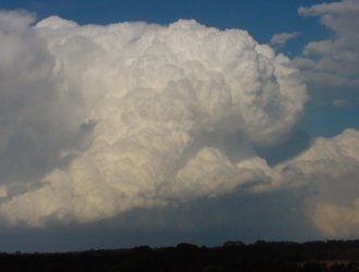
Going out
the door this morning I saw a TCU in the corner of my eye - it was then
I decided to bring the cameras to work just in case. (If it wasn't
for that cloud, I would have gone camcorder-less hehe). Anyway, at
work I was drooling as I looked outside and luckily I got out early at
2pm. I then flew up to the rooftop carpark and it was pouring down.
Several CGs struck around me and just as I parked the car under some hail
nets...can you guess???
Yep it hailed, and
it was driven by winds of 50-60km/h. Hailstones were just over pea
size (not severe) and despite being under the nets, the wind blew these
onto the car at times. Quite a racket!! My first hail for a
long time - by Brisbane standards. The hail lasted 3-4mins and soon
the rain melted most of it away.
I tried to stay under
the hail seeing it was not going to dent the car, but traffic conspired
against me. Instead, I found a number of clearings and took photos
of absolutely awesome Cb structure. I think I took the best part
of 2 rolls. I didn't forget to video that as well.
The last hour or
so I took more pics of the awesome Cb structures. Ahh...I love it!!!!!
Click here
or on the above photos to see James' report for this day
Michael Bath from Australian
Severe Weather also has a report on the storms in NE NSW.
Click here
or on the photos above to go to the report.
|